
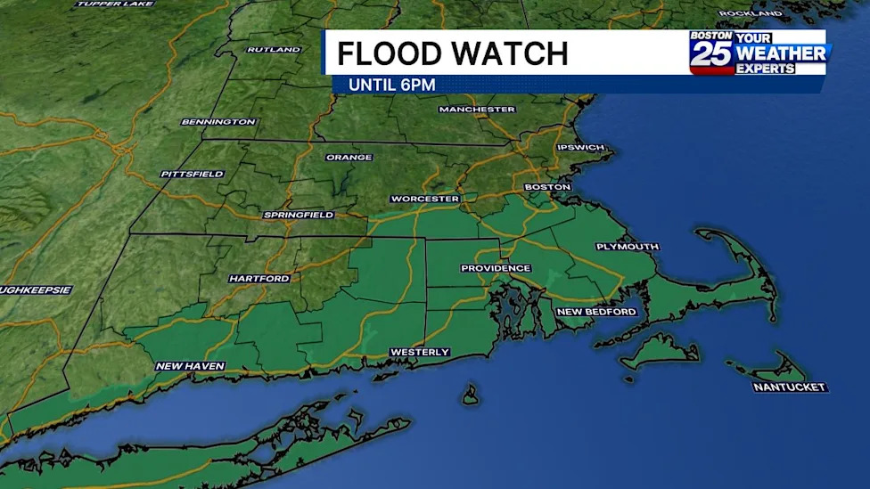
Severe weather advisories have been issued for broad sections of southern New England as a powerful storm system sweeps across the region, prompting forecasters to place several Massachusetts communities under an active flood watch. The alert highlights the imminent risk of torrential rainfall and localized flash flooding, particularly across communities situated along and south of the Massachusetts Turnpike. Residents throughout the affected zones are being advised to remain vigilant as rapidly changing atmospheric conditions threaten to overwhelm local drainage infrastructure and create hazardous travel environments through Sunday evening.
According to regional meteorological reports, the flood watch encompasses eight major Massachusetts counties: Suffolk, Norfolk, Worcester, Bristol, Plymouth, Barnstable, Dukes, and Nantucket. By spanning from urban centers in the greater Boston area through central Massachusetts down to Cape Cod and the neighboring islands, the advisory covers a diverse geographic landscape that includes densely populated municipal corridors, low-lying coastal terrain, and suburban transit corridors. The formal watch remains active through 6 p.m. on Sunday, covering the most critical window for heavy precipitation.
The Boston 25 Weather Team has placed the region on a Severe Weather Alert to ensure the public is prepared for the unfolding weather event. Forecasters noted that a concentrated cluster of heavy rain was positioned to push directly into southeastern sections of the state starting in the late morning hours. Meteorologist A.J. Mastrangelo outlined the trajectory of the disturbance, pointing out that rainfall activity would intensify as it tracked across southern Massachusetts, maintaining persistent flood concerns for communities located along and south of the Mass Pike throughout the afternoon.
The storm structure is characterized by scattered showers accompanied by embedded thunderstorms capable of generating intense downpours. Rather than delivering a steady and uniform rainfall across the entire state, the system is expected to produce localized, narrow bands of extreme precipitation. These compact bands of torrential rain can form rapidly, leading to highly variable rainfall totals across relatively short geographic distances and creating sudden hazards for unsuspecting drivers and local residents.
Broad projections indicate that most communities within the watch area will see widespread precipitation accumulations ranging from 0.50 to 2 inches. While these general amounts are manageable under normal drainage conditions, the true threat stems from the more concentrated storm cells embedded within the broader weather pattern. Meteorologists emphasize that baseline totals could escalate dramatically wherever sustained downpours become anchored over specific neighborhoods or watersheds.
Forecasters have warned that localized, narrow bands of precipitation could unleash between 2 and 4 inches of rain within a compressed three-hour timeframe. Rainfall rates of that magnitude present significant risks for rapid water accumulation, as the volume of water falling within a short window can quickly exceed the capacity of storm drains, streams, and retention basins, turning roadways and low-lying ground into hazardous watercourses.
The National Weather Service issued clear cautions regarding the inherent unpredictability of these concentrated rain bands. While meteorologists cannot determine with complete certainty exactly where these narrow swaths of intense precipitation will set up, the threat of flash flooding remains substantial. The weather service underscored that this danger will be particularly acute if a heavy band develops directly over vulnerable, highly developed urban areas where impermeable surfaces amplify runoff.
In densely developed municipal environments, such as those found across Suffolk and parts of Norfolk and Worcester counties, extensive pavement and concrete prevent water from soaking naturally into the ground. When multiple inches of rain fall in only a few hours over these urban centers, water quickly pools in underpasses, streets, and subterranean structures. The combination of intense downpours and high impervious surface coverage elevates the urgency of the National Weather Service's warnings.
To help residents navigate the potential disruptions caused by the storm, emergency management organizations and regional officials have highlighted multiple resources and response mechanisms. The Massachusetts Emergency Management Agency (MEMA) provides access to a real-time power outage viewer designed to keep the public informed about electrical grid status. This monitoring platform tracks active power interruptions across individual communities and statewide regions, providing real-time updates and utility company restoration estimates as repair crews respond.
In addition to electrical utility monitoring, MEMA maintains live weather radar systems and advanced forecasting tools to assist residents in tracking storm progression in real time. These visualization tools allow individuals to observe incoming precipitation bands and make informed decisions regarding travel, outdoor activities, and property protection as the cluster of heavy rain tracks across southern New England.
Regional public safety officials also point citizens toward vital support platforms such as Mass211, which serves as an essential channel for non-emergency information and community assistance during severe weather incidents. By utilizing these state-supported platforms, residents can access timely guidance without overburdening primary emergency communication channels needed for acute crisis responses.
Broader coordination extends to federal partners, with ongoing monitoring provided by the Federal Emergency Management Agency (FEMA) alongside multiple regional National Weather Service forecast offices. Both the NWS Boston office, which oversees the primary watch area, and the NWS Albany office in New York continue to evaluate atmospheric trends, analyze radar signatures, and refine forecasts to safeguard communities throughout the Northeast.
Forecasters with the Boston 25 Weather Team are actively delivering updates across broadcast and digital platforms, encouraging the public to monitor their Twitter channels for the latest radar trends, road conditions, and severe weather bulletins. Continuous digital updates provide an additional layer of awareness as conditions evolve on the ground and localized flooding risks materialize.
With the flood watch scheduled to remain in effect until 6 p.m. Sunday, officials and meteorologists urge all residents south of the Mass Pike to exercise caution, avoid navigating through flooded roadways, and remain prepared for swift changes in weather conditions. By utilizing available forecasting tools, monitoring emergency resources, and tracking localized rainfall rates, community members can better protect themselves and their property against the hazards of sudden flash flooding.





(0)